Avoid fence placement mistakes that could cost you thousands. Installing a fence without confirming your property lines can lead to legal disputes, forced removals, and unexpected expenses. A misplaced fence can result in fines, adverse possession claims, or even title insurance complications. Here’s what you need to know:
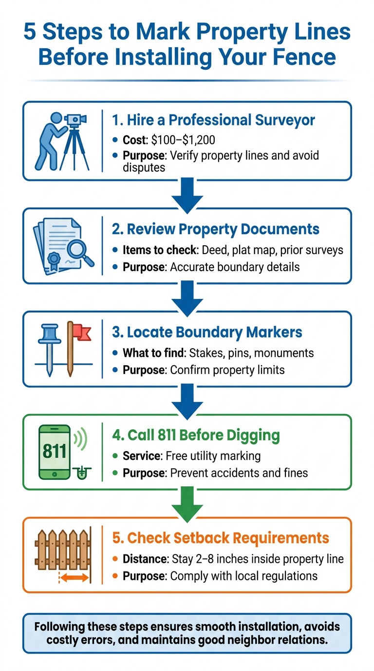
- Boundary Survey: Hire a professional surveyor ($100–$1,200) to verify property lines and avoid disputes.
- Property Documents: Review your deed, plat map, and prior surveys for accurate boundary details.
- Physical Markers: Locate or replace boundary markers like stakes or pins to confirm property limits.
- Utility Safety: Call 811 before digging to mark underground lines and prevent accidents or fines.
- Setback Rules: Ensure your fence complies with local regulations, staying 2–8 inches inside your property line.
Taking these steps ensures a smooth installation process, avoids costly errors, and maintains good neighborly relations. Keep essential documents like surveys, permits, and utility tickets for future reference.
5-Step Property Line Verification Process Before Fence Installation
Property Lines and Boundaries Explained
What Property Lines Are
Property lines, also referred to as boundary lines, are the official legal borders that outline where your property ends and your neighbor’s begins. These boundaries are documented in property deeds, subdivision maps, and survey markers. Unlike fences or other visual markers, property lines are precise and legally binding.
"Property lines define where property begins and ends. It sounds simple, but property line disputes can create severe problems between neighbors."
- Mizuki Hisaka, Contributing Writer, Angi
These lines play a crucial role in determining what you can build or plant on your land. They also clarify who is responsible for maintaining fences. For instance, if a fence is entirely on your property, you’re responsible for its upkeep. However, if it sits directly on the boundary, you and your neighbor typically share the maintenance costs.
Knowing your property boundaries can help you avoid encroaching on someone else’s land – a mistake that could lead to legal disputes, title issues, and even court-ordered removals. Encroachments can also affect your title insurance, as they are often treated as exceptions, reducing the coverage you receive.
Common Boundary Identification Problems
Even though property lines are legally established, finding them on the ground isn’t always straightforward.
One common issue is missing or disturbed markers. Stakes or iron pins marking the boundaries can be buried, displaced during construction or utility work, or lost over time. Fences and hedges, often assumed to mark property lines, rarely match the legal boundaries.
Another challenge is outdated documentation. Older property deeds might reference landmarks like specific trees or stone walls that no longer exist. Additionally, older subdivision measurements may not align perfectly with recorded dimensions, often differing by 0.5 to 2 feet due to cumulative errors.
Unclear boundaries often spark disagreements between neighbors. These disputes can involve issues like fence placement, overgrown vegetation, or shared maintenance responsibilities. In some cases, even a small encroachment – just 1 to 3 feet – can lead to adverse possession claims, particularly in states with shorter statutory periods of 10 years or less.
sbb-itb-d1d0a96
Finding and Marking Property Lines
How to Identify Your Property Lines
Before setting up a fence, it’s essential to confirm your property boundaries. You can do this by reviewing property documents, locating physical markers, and using online mapping tools.
Checking Property Documents
Start with your property deed, which contains a written description of your boundaries. These descriptions often reference landmarks like trees or creeks and include precise measurements. If the details seem unclear, older deeds might provide additional context.
Another helpful resource is a plat map, which outlines the layout of your neighborhood or subdivision. It identifies individual lots, parcel numbers, and property dimensions. You can usually obtain these maps from your local assessor’s office or zoning department for a small fee, often under $25.
For the most accurate information, consult a property survey. Surveys use "metes and bounds" descriptions to pinpoint exact boundary lines. Check your home closing documents for a recent survey – it could save you the cost of ordering a new one, which typically ranges from $330 to $670.
Once you’ve reviewed your documents, the next step is to locate physical markers on your property.
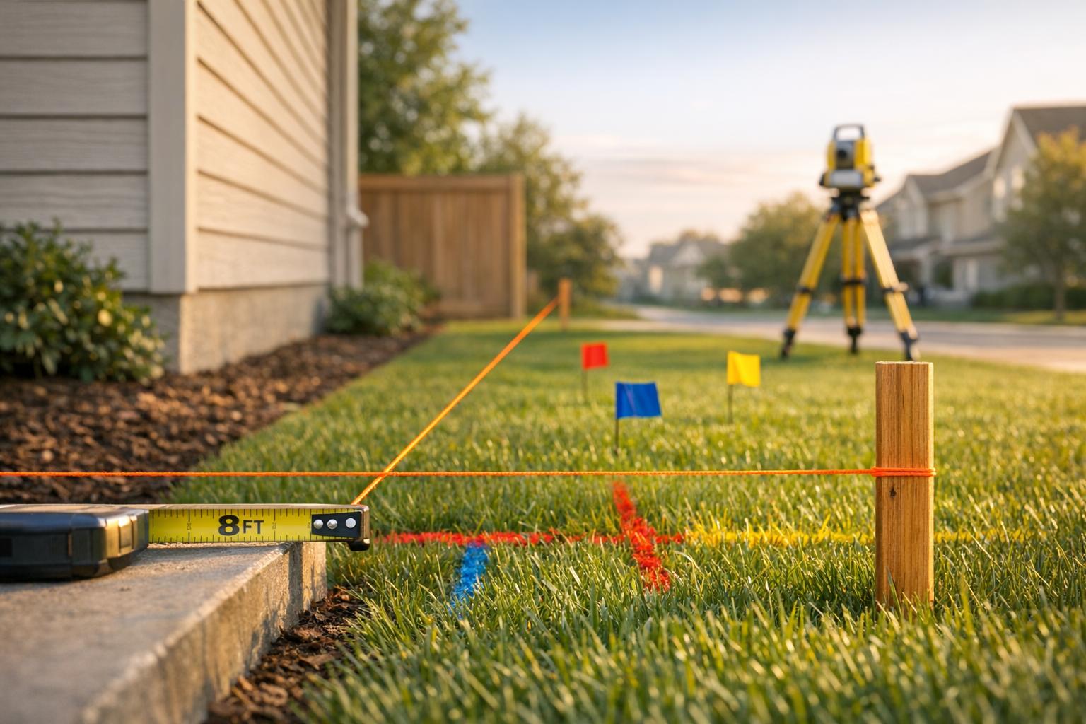
Finding Physical Boundary Markers
Professional surveyors place metal pins or concrete monuments at property corners to mark boundaries. These markers, often 2 to 3 feet long, may be flush with the ground or buried 10 to 12 inches deep. Some include plastic caps for easier identification.
To locate these markers, start at the corners of your lot, near the curb or sidewalk. Look for temporary wooden stakes or colored flags that might be near permanent markers. Sidewalk joints or changes in concrete texture can also align with property lines.
If you can’t see the markers, try using a metal detector. Before digging, always call 811 to avoid damaging underground utility lines. As Jonathon Lord, Managing Partner at Carolina Land Surveying, suggests:
"In the newest subdivisions, (homeowners) can kind of do it themselves if they’re comfortable with a tape measure".
Be cautious with existing fences – they don’t always align with legal property boundaries. Mike Stanley, Owner of Stanley Land Surveying, advises:
"If the fence was built and they didn’t get a survey, they built it where they thought the line would be".
Using Online Mapping Tools
If documents and markers leave you uncertain, online tools can provide a quick overview of your property layout.
County GIS (Geographic Information System) tools are a reliable option, offering official parcel data and boundary lines maintained by local governments. To find your county’s GIS tool, search ".gov search property records in [COUNTY NAME]" to ensure you’re accessing an official government website.
Google Maps can also display property boundaries, though its accuracy may be limited. To use it, enter your address and zoom in on the red pin until faint gray lines appear. Additionally, apps like LandGlide or Regrid can provide more detailed parcel data.
When You Need a Professional Land Surveyor
While reviewing property documents and searching for boundary markers can give you a general idea of your property layout, there are times when you need the precision and expertise of a licensed professional land surveyor. Their involvement ensures accuracy and offers legal protection in critical situations.
Reasons to Hire a Surveyor
If boundary markers are missing or have been disturbed – perhaps buried during landscaping projects or displaced by utility work – a surveyor can step in. Using deed calls and adjoining plats, they can reconstruct the boundaries even in the absence of physical markers.
Neighbor disputes are another scenario where a surveyor’s expertise is invaluable. A certified survey provides legally defensible evidence of boundary lines. As John Shum of ArcSite puts it:
"A survey transforms your fence layout from a guess into a plan backed by defensible data".
This documentation can help you avoid costly legal disputes and the potential hassle of removing a fence built in the wrong location.
Building close to your property’s edge is another situation where hiring a surveyor is crucial. In older subdivisions, boundary deviations of 0.5 to 2 feet are not uncommon, which could lead to encroachments of 1 to 3 feet. Such errors might even result in adverse possession claims. A professional survey ensures your fence stays within your property lines, avoiding these risks.
For irregularly shaped lots or properties with complex boundary descriptions, a surveyor’s skills are essential. They can translate confusing metes and bounds descriptions into clear, precise boundaries.
Surveyors also identify easements and setbacks that could restrict where you place a fence. This prevents costly mistakes, like having to remove a fence that encroaches on an easement or violates setback requirements.
In short, a professional survey doesn’t just identify boundaries – it provides legally binding documentation that protects your property rights.
What a Professional Survey Provides
A professional survey typically costs between $400 and $1,200 and, in Florida, takes about 3–7 business days to complete. Many homeowners commission surveys specifically for fence installation.
The surveyor begins by researching county records and deeds to confirm your property’s legal description. They then conduct field measurements using specialized equipment to locate existing monuments or establish new ones. At key points, they install physical markers – such as stakes, iron pins, or brass caps – often flagged with brightly colored ribbons to guide fence placement.
Once the work is complete, you’ll receive a certified survey drawing. This document clearly shows:
- Exact boundary locations with bearings and distances
- The types and positions of corner markers
- The relative positions of existing structures
- Any recorded easements or rights-of-way
This survey is not just a map – it’s a legally binding document that can be used in court proceedings or to obtain building permits.
Additionally, the survey offers legal protection against potential encroachment claims. Title insurance underwriters often require such surveys to clear "Schedule B" exceptions. As Fence Installation Authority emphasizes:
"A building permit does not constitute a survey, does not establish the property line, and does not protect against an encroachment claim from an adjacent owner or easement holder".
Hiring a professional surveyor ensures your project is backed by accurate, defensible data, saving you from potential legal headaches down the road.
Locating Utilities and Following Safety Rules
Once you’ve confirmed your property boundaries, the next step is ensuring your site is safe by identifying underground utilities. Even with well-marked property lines, digging for fence posts without checking for utilities can lead to injuries, service disruptions, and steep repair costs. Since fence posts often go 24–48 inches deep, there’s a real chance of hitting gas, electric, or water lines.
Calling 811 Before You Dig
In the U.S., it’s mandatory to notify 811 before starting any digging project, including fence installation. This free service alerts utility operators – usually around 7 to 8 per request – who will send professionals to mark underground lines at no cost to you. For example, in Texas, you can use the Texas811 portal to submit your request at least 48 hours before digging.
To help locators focus on the right area, mark your planned fence line with white paint or flags before they arrive. If you’re working with a contractor, ensure they have a valid 811 ticket number before starting. Remember, the party doing the digging is typically responsible for any damage to utilities.
It’s important to note that 811 only marks public utility lines. Private lines, like those for irrigation systems, landscape lighting, or pool heaters, won’t be included. You may need to hire a separate service to locate these. Also, locate tickets expire after 15 to 30 days. If your project gets delayed or the fence layout changes, you’ll need to submit a new request.
Once the utilities are marked, knowing how to interpret those markings is key to digging safely.
Reading Utility Markings
Utility locators use specific colors to identify the type of underground infrastructure. Here’s a quick guide:
- Red: Electric power lines
- Yellow: Gas or petroleum lines
- Orange: Communication cables
- Blue: Potable water lines
- Green: Sewer lines
- Purple: Reclaimed water or irrigation systems
These markings show the horizontal path of the utility but don’t indicate how deep they are, as depth can vary over time.
For safety, always maintain an 18 to 24-inch buffer zone on either side of any utility marking. Within this zone, avoid using power tools like augers. Instead, stick to hand tools like shovels or vacuum excavation to avoid damaging the lines.
As OSHA Standard 1926.651(b) states:
"The estimated location of utility installations, such as sewer, telephone, fuel, electric, water lines, or any other underground installations that reasonably may be expected to be encountered during excavation work, shall be determined prior to opening an excavation."
Ignoring this requirement can lead to civil penalties, full liability for repair costs, and even criminal charges if someone gets hurt.
Getting Your Property Ready for Fence Installation
Preparing your property correctly is crucial for a smooth fence installation process that complies with all necessary regulations.
Marking the Fence Path
Start by identifying key points like property corners, gate posts, and direction changes. Use wooden or fiberglass stakes to mark these spots. To ensure precise 90-degree angles, apply the 3-4-5 rule: measure 3 feet along one side, 4 feet along the other, and confirm the diagonal measures exactly 5 feet. For longer distances, scale up proportionally (e.g., 6-8-10) to maintain accuracy.
Once you’ve marked the corners, stretch a mason’s line or braided nylon string tightly between the stakes at the desired height of your fence posts. This creates a consistent reference for your fence’s alignment. Be sure the string is taut and free of sagging. Mark the post centers along this line at your chosen spacing – commonly 6, 8, or 10 feet apart. After marking, offset the measurements 4 to 6 inches perpendicular to the string. This adjustment allows you to reset the line accurately after digging the post holes. If your property has a slope, use a line level or laser level to check grade changes and decide whether to "rack" the fence (follow the slope) or "step" it (install level panels).
Lastly, confirm that your fence layout aligns with local regulations and any easement restrictions.
Checking Regulations and Easements
Before proceeding, review local rules to ensure your fence complies with setbacks and easement restrictions. These rules often overlap, including state property laws, municipal zoning codes, and, where applicable, homeowner association (HOA) guidelines.
Check your title report for easements, which are legal rights that might limit where you can place a fence. For example, utility easements often extend 10 to 20 feet along rear property lines. Remember, property boundaries are determined by professional surveys based on legal descriptions – not just visible yard features. Fences built within easement areas could be removed at the easement holder’s discretion.
If your property is on a corner lot, verify visibility triangle requirements designed to maintain clear sightlines for traffic safety. Additionally, homeowners in HOA communities should review their Covenants, Conditions, and Restrictions (CC&Rs) for specific height or material requirements. Obtain written approval from the HOA when necessary.
Keeping Required Documentation
Keep a detailed project file for reference during installation and any future inspections. This file should include:
- A professional boundary survey
- An approved building permit
- A site plan showing the planned fence route
- Your 811 utility locate ticket and documentation of utility markings
Utility locate tickets typically expire after 15 to 30 days, so be prepared to request a new one if there are delays. It’s also important to note that building permits confirm compliance with codes but do not establish property boundaries.
If your state requires notifying neighbors about shared boundary fences (e.g., California Civil Code §841), retain copies of all related communications.
For expert help with these steps, contact Tend Fencing (https://tendfencing.com). Their experienced team can ensure your project meets both technical and regulatory requirements.
Conclusion
Defining your property lines correctly is essential to avoid costly legal disputes and ensure compliance with local regulations. Begin by examining your property deed and plat map, and then verify the location of physical boundary markers to confirm your property limits. If boundaries are unclear or contested, hiring a licensed professional land surveyor can provide the legal accuracy needed to establish property corners. As 76 Fence warns:
"Placing your fence in the wrong spot can lead to expensive problems, such as having to relocate or remove the fence."
Safety is equally important. Before digging, always call 811 to have underground utilities marked. Fence post holes often exceed 18 inches in depth, which could interfere with buried gas, electric, or telecommunications lines. This free service helps prevent dangerous accidents and limits legal risks.
When planning your fence, use stakes and a taut string to outline the path, applying the 3-4-5 rule to ensure square corners. Keep the fence 2–8 inches inside your property line and avoid encroaching on utility easements, which typically extend 10 to 20 feet along rear property lines.
Maintain a project file with all essential documents, including surveys, permits, site plans, and 811 tickets, for future reference. While these steps may take time, they are far less costly than dealing with forced removal, neighbor disputes, or title issues down the road.
Once you’re ready to proceed, Tend Fencing (https://tendfencing.com) can assist you from start to finish – ensuring your fence is installed correctly and meets all technical and regulatory requirements.
FAQs
Is a new survey really necessary before I build a fence?
Before putting up a fence, it’s a smart move to get a new property survey. Why? It ensures you know exactly where your property lines are. This helps you avoid placing the fence on your neighbor’s land, which could lead to disputes or even legal trouble. Plus, having a survey can make it easier to comply with local permitting rules and setback regulations. Accurate measurements from a survey give you peace of mind that your fence is built entirely within your property boundaries.
What if my neighbor disagrees with where the property line is?
If you’re facing a property line dispute with your neighbor, the best first step is to have an open and honest conversation. Sometimes, a simple discussion can clear up misunderstandings and help you both come to an agreement.
If talking it out doesn’t work, consider hiring a professional land surveyor. They can accurately determine the boundaries of your property and provide official documentation to back it up. This can be incredibly helpful in clarifying the situation.
For disputes that remain unresolved even after a survey, it might be time to seek legal advice or explore mediation. These steps can help protect your property rights and prevent issues like encroachment or trespassing.
In the end, clear communication and professional surveys are often the most effective ways to handle and avoid property line conflicts.
Can I put a fence inside a utility easement?
Generally, installing a fence within a utility easement is not allowed. These areas are set aside to ensure utilities have access for maintenance or repairs, and a fence could create legal complications or obstruct their work. To steer clear of potential problems, it’s wise to hire a professional surveyor to pinpoint the exact boundaries of the easement before starting any construction.